HHARP Module 2 – Hazard Awareness
Module 2 Overview
- Covers six (6) Natural Hazards
- Approximately 2 hours for each hazard
- Two sections of Module 2:
- Section 1: Train the Trainer
- Section 2: Educating the Community
- Worksheets
Module 2: Milestones

2A. The HHARP Program Record reflects that the community has held five or six outreach sessions covering tropical cyclone, flood, tsunami, earthquake, wildfire, and volcano (as applicable) hazards. Each outreach session has engaged a representative number of community members.
2B. Program Record reflects that the community has completed Parts 1-3 of Worksheet B for all relevant hazards, which included:
- Identifying hazards likely to impact the community.
- Developing hazard profiles for likely hazards.
- Obtaining maps of known hazard zones.
Module 2: Key Tasks
-
Worksheet B: Hazard Assessment
Identify the hazards most likely to impact your community and create hazard profiles for priority hazards.
-
Form A Working Group
Research and obtain maps of known hazard zones in your community.
-
Complete Worksheet B
Complete Part B of Worksheet B. Compare results for planning purposes and for use in Module 4 activities.
Natural Hazards

Six (6) Natural Hazards:
Earthquakes, Floods, Tropical Cyclone, Tsunami, Volcanoes, and Wildfires
•Science
•Local impacts
•Notable events
••Alerts & Warnings for each particular hazard
Module 2: Volcano Basics
What is a Volcano?
An opening in the earth’s crust that allows molten rock, gases, and debris to escape to the surface during a volcanic eruption.
Active Volcanoes in Hawai‘i
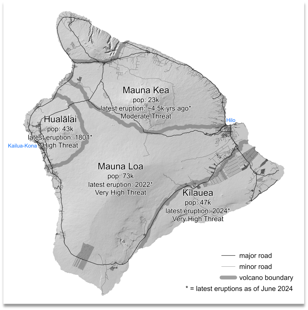
| Name of Volcano | Location of Volcano | Date of Last Eruption | Threat Potential / Areas at Risk |
| Kīlaueʻa | County of Hawaiʻi | September 2024 | Very high threat potential Areas: Puna district, Kaʻū and Hawaiʻi Volcanoes National Park |
| Mauna Loa | County of Hawaiʻi | November-December 2022 | Very high threat potential Areas: South Hilo, Puna, Kaʻū, South Kona, North Kona and South Kohala |
| Hualālai | County of Hawaiʻi | 1801 | High threat potential Areas: North Kona district |
| Haleakalā | County of Maui | Late 1700s | Moderate threat potential Areas: Hāna, Kēōkea, Kula, Pukalani, and Wailea-Makena. |
| Mauna Kea | County of Hawaiʻi | Between 6,000 and 4,000 years ago | Moderate threat potential |
| Kamaʻehuakanaloa (underwater volcano), formerly Lōʻihi | County of Hawaiʻi (located 22 miles southwest) | 1996 | Low to very low threat potential |
Volcanic Eruption Associated Hazards
-
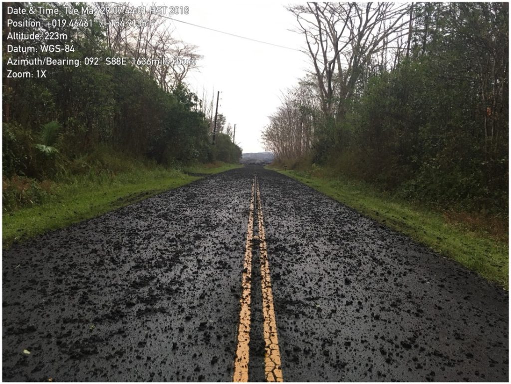
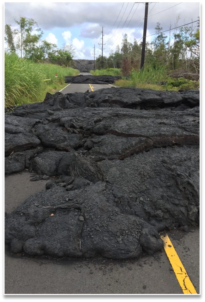
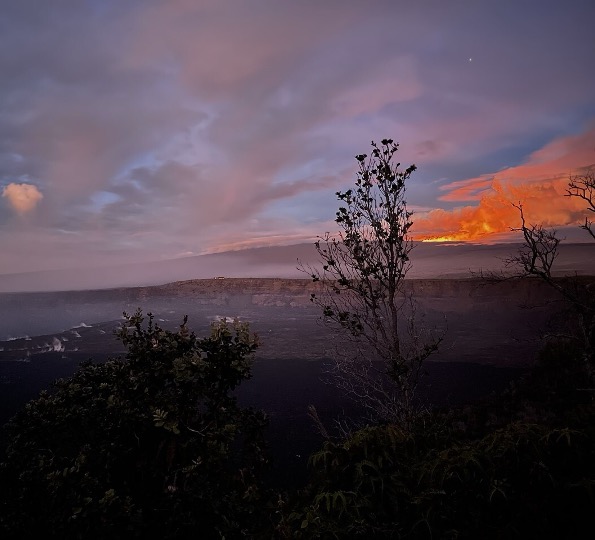
Lava flows
-
VOG (Volcanic Smog)
-
Laze & Littoral Explosions
-
Tephra & Volcanic Ash
-
Pele’s Hair / Volcanic glass
-
Earthquakes
Associated Hazard Lava Flow
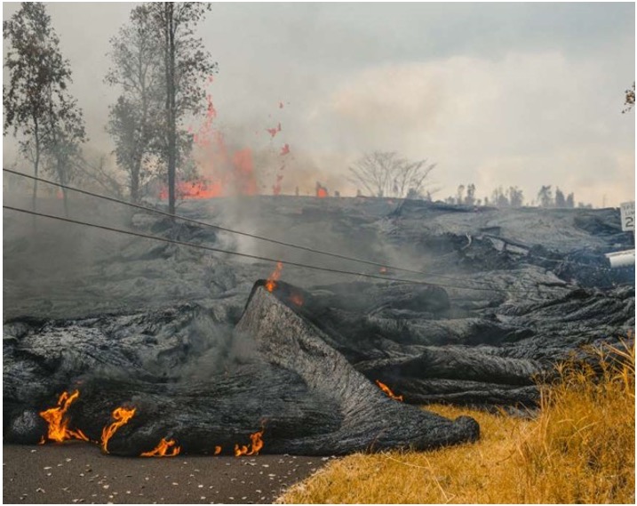
Streams of molten rock that pour or ooze from an erupting vent
Destroys / Buries buildings, property, agricultural crops, etc.
Speed of movement depends on:
•Type and viscosity of lava
•Steepness of the terrain
•Rate of lava production
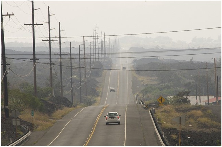
Associated Hazard Vog
Volcanic smog caused by volcanic emissions
•Aerosols of sulfuric acid produced by sulfur dioxide (SO2) gas and atmospheric moisture.
•Vog is not limited to the eruption site.
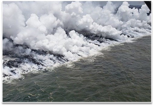
Associated Hazard Laze & Littoral Explosions
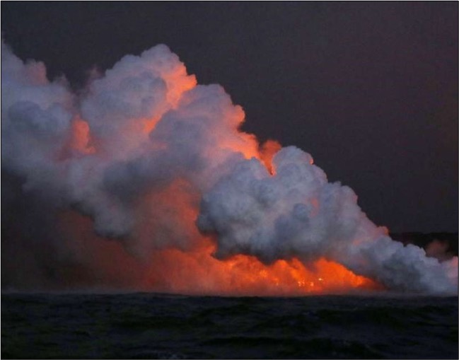
Acidic plumes with high concentrations of hydrochloric acid
Laze – gaseous
Littoral – particles
•Occurs when molten lava flows into the ocean and reacts with sea water.
•Inhaling or contacting acidic gases and liquids can irritate skin, eyes and respiratory tract and may cause breathing difficulties, especially for people with pre-existing respiratory diseases.
Associated Hazard Tephra / Volcanic Ash
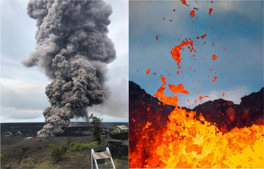
Volcanic fragments of rock and ash produced when magma is explosively ejected (pyroclastic material).
•Large fragments or “coarse tephra” (>2.5 inches in diameter) can be expelled with great force and are deposited near the eruptive vent.
•Smaller fragments can be carried upward within a volcanic plume, then fall to the ground as the cloud cools.
•Tephra also includes ash, cinders, blocks and bombs.
Volcanic ash plumes resulting from gas or steam explosions
•Plumes are composed of tiny rock and glass particles (sand or dust –sized).
•Inhalation hazard to communities downwind from
emission sites.
•Falling ash can injure eyes, breathing passages, open wounds and can irritate the skin.
•Can reduce visibility and make roads slippery (last is uncommon in Hawai‘i).
Associated Hazard Pele’s Hair

Volcanic glass, also referred to as “Pele’s Hair”
•Another form of tephra
•Formed from lava fountains and fast-moving lava flows
•Long, thin strands or fibers of volcanic glass
•Eye and skin irritant
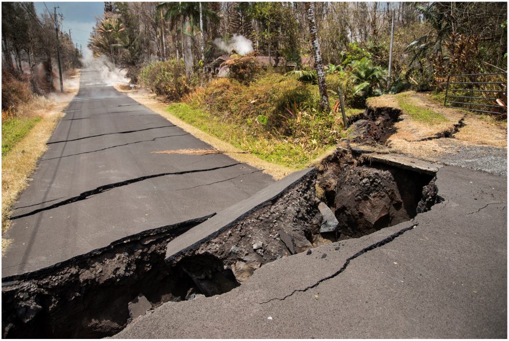
Associated hazard Earthquakes
Earthquakes can trigger tsunami, damage structures, roads, and other critical infrastructure.
Impacts of Volcanic Eruptions
-
Health
-
Agriculture
-
Water Systems
-
Socio-Economic
-
Numerous socio-economic and environmental impacts
Impact on Human Health
Volcanic emissions (e.g., SO2, vog, volcanic ash) can be hazardous to your health
•Especially for the elderly, young children and people with respiratory problems.
•Certified N-95 masks may help protect against volcanic ash, but do NOT protect against dangerous gases such as SO2 (sulfur dioxide).
Sulfur Dioxide Gas Emissions
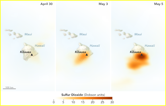
May 2018 Kīlauea eruption
Impact on Agriculture
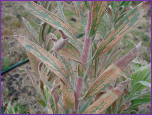
Volcanic emissions injure plant tissue
•Sulfur dioxide (SO2) gas & vog is particularly damaging.
•Acidic gases can chemically burn leaves.
•Heaviest damage occurs close to and downwind of the volcano.
Impact on Water Catchment Systems
Vog causes water to become acidic and can leach harmful contaminants, such as lead, copper, and zinc, from roofing and galvanized plumbing materials, especially on older homes.
Catchment systems should be monitored, maintained and tested routinely.
Socio-economic Impacts
•Permanent property loss
•Homelessness
•Loss of access/services
•Economic downturn in affected areas
•Decline in tourism
Notable Eruptions
Last 150 years
Mauna Loa, 1880-1881 – Hilo Town
Flow advanced from Mauna Loa’s Moku’āweoweo
northeast rift zone to 1.1 miles (1.7 km) from Hilo Bay before it stalled.
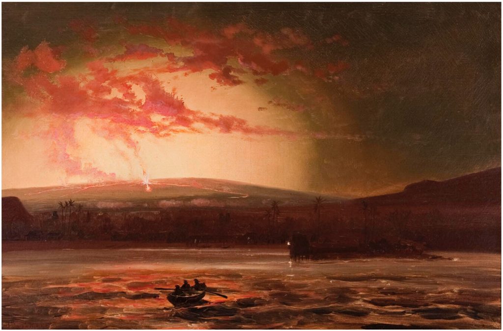
Mauna Loa, 1984 – Hilo Town
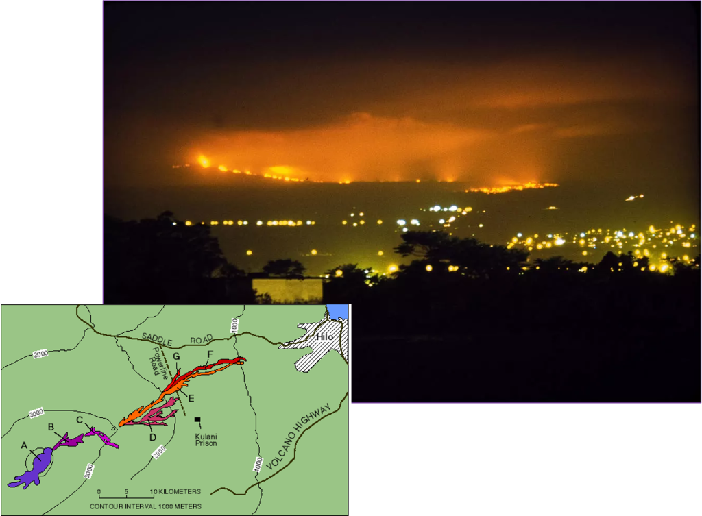
Eruption began from the Mokuʻāweoweo vent on Mauna Loa’s northeast rift zone on March 24, 1984.
Eruption ended on April 15.
Pre-eruption earthquakes “became so constant that nearby telescopes on Mauna Kea could not be stabilized.” [USGS]
Kīlauea, 1990 – Kalapana
Kīlauea’s Kupaianaha vent destroyed and partially buried:
Kalapana Gardens
Royal Gardens
The town and black sand beach of Kaimū.
Hakuma horst (fault block on the left) directed the flow toward Kalapana.
Eruption in 2010 flowed into the same area, destroying 1 house.
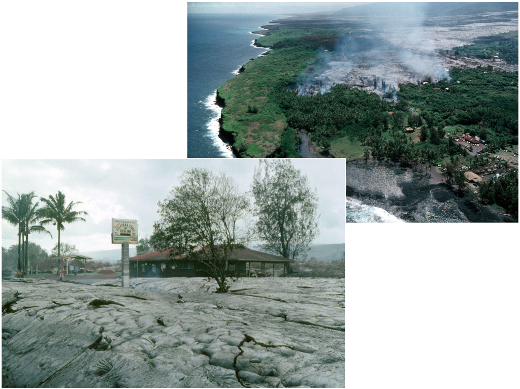
Kīlauea, 2014 – Pāhoa Town
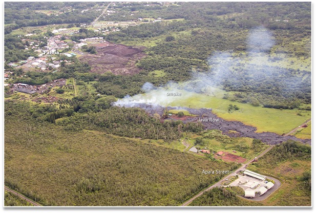
Months after flowing through forest southwest of Pāhoa, the flow entered residential property in October 2014.
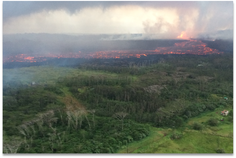
Kīlauea, 2018 – Lower Puna, Lower East Rift Zone
Fissure Eruptions
24 fissures eventually opened.
Summit Activity
The lava lake within Halemaʻumaʻu crater drained, causing the caldera floor to collapse.
Numerous earthquakes occurred beneath the summit and nearby.
Intermittent ash emissions and explosions occurred.
Kīlauea, 2018 – Lower Puna
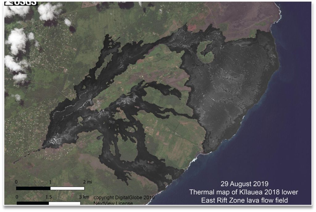
Lava Flow Map
•6,000+ acres inundated by lava
•700+ structures destroyed
•Hawaiʻi County Civil Defense photos and videos of the eruption:
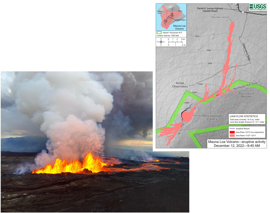
Mauna Loa, 2022 – Saddle Road
Eruption began from the Mokuʻāweoweo vent on Mauna Loa’s northeast rift zone on November 27, 2022
Eruption ended on December 13, 2022.
Eruption cut off access to a service road to the atmospheric carbon dioxide measuring station on Mauna Loa.
Flow ran for 12 miles, threatening to cut off Saddle Road, a vital highway between Hilo and Kona.
Haleakalā – Dormant
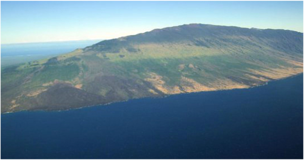
The most recent eruption on Haleakalā was probably between A.D. 1480 and 1600.
Haleakalā is monitored by a continuous GPS instrument and seismometer located near the southwest edge of the summit crater.
Hazard Zones
Lava Flow Hazard Zones, County of Hawaiʻi
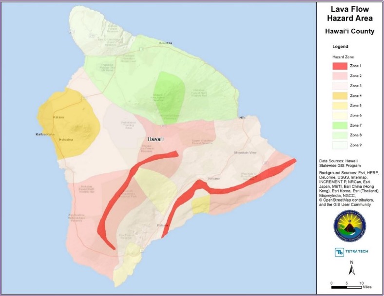
Zone 1 (red) includes –
Summits and rift zones of Kīlauea and Mauna Loa, where vents have been active since written records have been kept, ca. 1800 CE.
Travel times projections for Mauna Loa Eruption.
Based on ʻāʻā flow rates from Mauna Loa in 1950.
Pāhoehoe lava typically flows more slowly.
Lava Flow Hazard Zones, Maui County
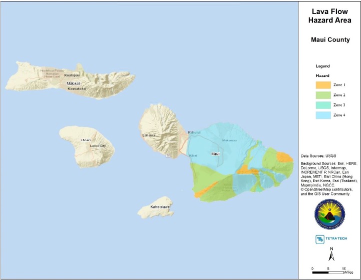
Zone 1 (orange)
Haleakalā Crater
•The east and southwest rift zones
•A portion of the northern flank of the east rift zone
•All areas where eruptions have occurred frequently in the past 1500 years.
Alert and Warning
Volcano Alert and Warning in Hawai‘i
USGS
Hawaiian Volcano Observatory (HVO)
Responsible for notifying emergency managers and the public about volcano unrest and eruptive activity.
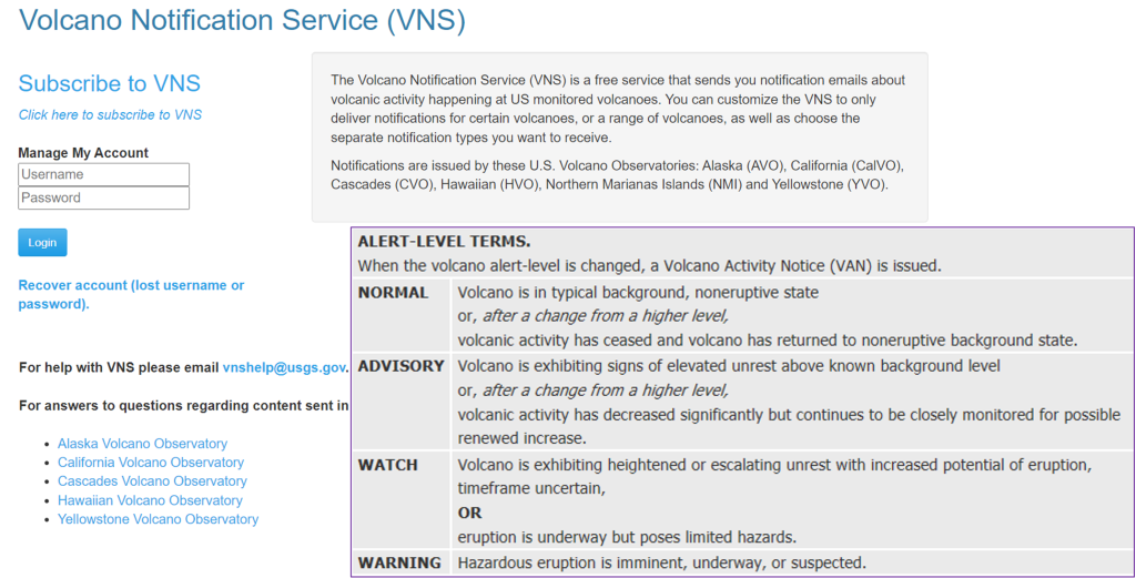
Volcano Notification Service (HVO)
Volcanic activity is generally preceded by earthquakes
USGS Volcano Notification Service (VNS)
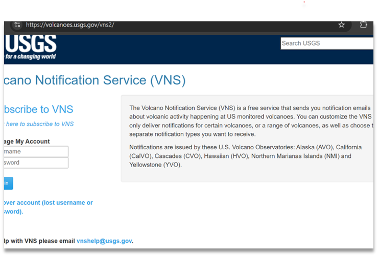
•Free service that sends automated notification emails about volcanic activity happening at US monitored volcanoes.
•Users can customize for certain volcanoes, range of volcanoes, and separate notification types to receive.
USGS Earthquake Notification Service (ENS)
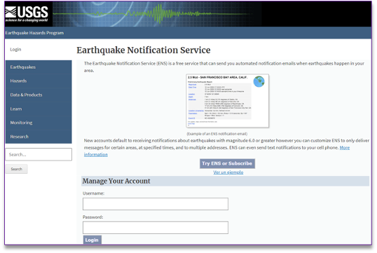
Earthquake Notification Service
•A free service that sends you automated notification emails when earthquakes happen in your area.
•Default notifications are sent for earthquakes of magnitude 6.0 or greater.
•Users can customize for magnitude, location, time of day, and multiple email addresses or text to cell phone.

If You Need to Evacuate Your Home
During an Event
•When the alarm sounds or officials instruct you to evacuate, do so immediately.
•Don’t wait until flood waters or storm effects are all around you to evacuate!
•Take your Disaster Supply Kit with you.
•Take your pets with you.
•Follow official advice to get out of the hazard zone.
For More Information
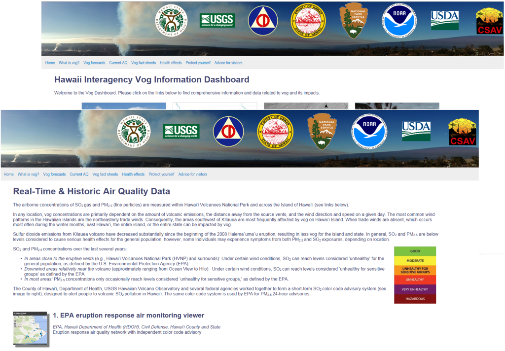
Multi-agency websites offer numerous tools and resources to inform the public about vog and other volcanic hazards:
Hawaii Interagency Vog Information Dashboard
Hawai‘i Volcanoes National Park Air Quality Monitoring
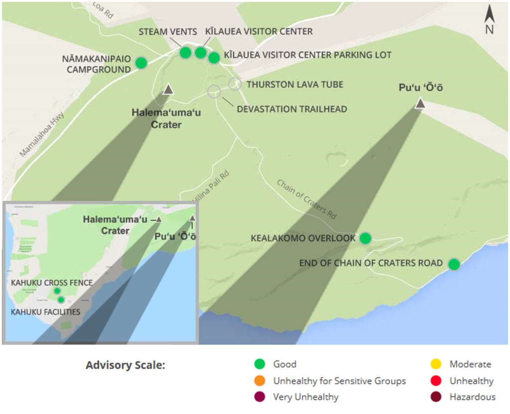
Air quality at Kīlauea is affected by volcanic sulfur dioxide gas (SO2) and particulate matter (PM2.5).
Unhealthy levels of these pollutants can occur within the park. People with pre-existing respiratory conditions are especially sensitive to poor air quality.
Safety Tips
Prepare NOW
Take steps to prepare before a volcano threatens
-
Know your Risk; Understand your area’s risk to volcanic eruption
-
Know where to go; Ask local emergency management for evacuation and shelter plans
-
Learn about community warning systems
Sign up for free notifications about volcanic activity at https://volcanoes.usgs.gove/vns2/
-
Get needed supplies; In case you need to evacuate immediately or if services are cut off.
-
Remember medications and supplies for pets
-
Consult with your doctor; If you have existing respiratory difficulties
Immediate Response Actions
During a Volcanic Eruption
Stay safe when a volcano threatens
-
Listen to alerts; The USGS Volcano Notification System (VNS) provides up-to-date information about eruptions
-
Follow evacuation orders; From local authorities. Evacuate early
-
Avoid areas downwind of the volcano; Tephra and ash will be carried by wind and gravity
-
Take temporary from volcanic ash; If you have enough supplies. Cover ventilation openings and seal doors and windows.
-
If outside, protect yourself from hazardous gases and falling ash; Volcanic gases and ash can irritate skin and injure breathing passages, eyes, and open wounds
For More Information
Hawaiian Volcano Observatory (USGS)
•https://www.usgs.gov/observatories/hvo
National Weather Service – Earthquake/Tsunami
•https://www.weather.gov/phi/earthquakes
State of Hawai‘i Department of Health
•https://health.hawaii.gov/prepare/advisories/big-island-volcanic-eruption/
USGS Earthquakes
•https://www.usgs.gov/programs/earthquake-hazards/earthquakes
Hawai‘i Emergency Management Agency
City & County of Honolulu Department of Emergency Management
Maui County Emergency Management Agency
www.co.maui.hi.us/index.aspx?nid=70
Hawai‘i County Civil Defense Agency
www.hawaiicounty.gov/civil-defense
Kaua‘i County Emergency Management Agency
Flood Basics
Contents
- Understanding Floods
- Types of Flooding in Hawai‘i
- Effects of Flooding
- Notable Flood Events
- Flood Hazard Zones
- Alert and Warning
- Flood Safety
What is a Flood?
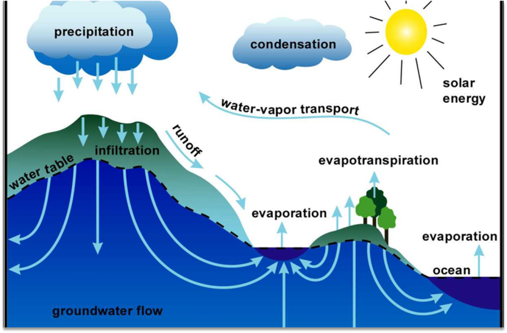
Understanding Floods
Flood: Overflow of water onto lands used or usable by society not normally covered by water.
•Inundation of land is temporary.
•Land is adjacent to and inundated by overflow from a river, stream, lake, or ocean. (USGS)
Hydrology: Science dealing with the occurrence, circulation, distribution, and properties of the waters of the earth and its atmosphere.
Factors That Contribute to Floods
- Rate of precipitation (rainfall)
- Amount of rain (inches or millimeters) over a specific time period
- Topography (slope)
- Ground conditions (soil type and condition)
- Saturation level of soil
- Vegetation (presence or lack of trees, grass, etc.)
- Water levels in rivers and streams prior to rainfall
- Condition of hydraulic structures (e.g., dams)
- Conditions of coastal areas (distance + elevation from ocean) – how far away and high up
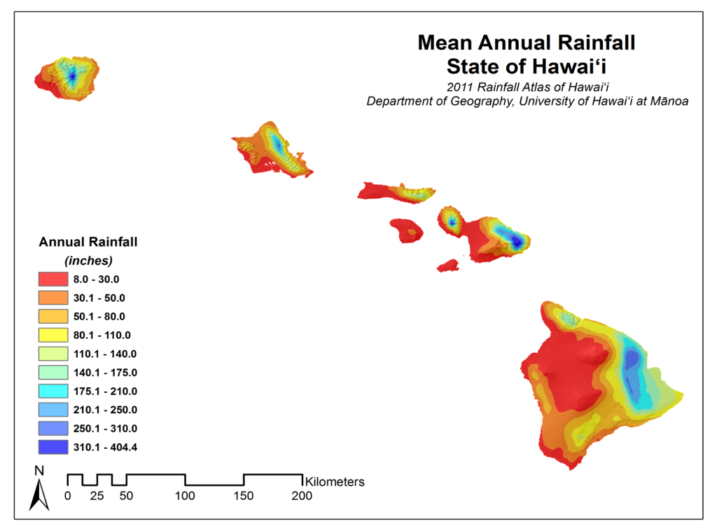
The Mountain Effect
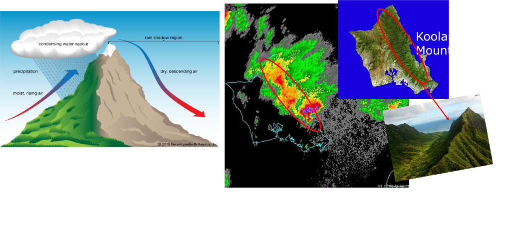
Orographic Lifting
Mean Annual Rainfall State of Hawai‘i
Flood Magnitude & Frequency
Recurrence intervals or probability of occurrence
Flood Events:
•“500-year flood” 0.2% chance of occurring in any given year.
•“100-year flood” 1% chance of occurring in any given year.
•“50-year flood” 2% chance of occurring in any given year.
•“25-year flood” 4% chance of occurring in any given year.
•“10-year flood” 10% chance of occurring in any given year.
“The State of Hawai‘i experienced 96 flash flooding events and 654 heavy rain events that led to flooding between 2018 and 2022”.
The state has a 40% chance (or two declarations every five years) of receiving a FEMA declaration for event-based floods in any given year.”
– SHMP, NOAA NCEI
Special Flood Hazard Area (SFHA)
•Area defined using the 100-year flood event. SFHAs are used by the National Flood Insurance Program (NFIP) to determine flood insurance requirements.
• Highlighted in the State of Hawai‘i’s State Hazard Mitigation Plan, pp. 4.6-9 to 4.6-14.
500 Year Flood Video
Types of Flooding in Hawai‘i
•Flash flooding
•River/Stream flooding
•Coastal flooding
•Urban flooding
•Dam Failure
Flash Flooding
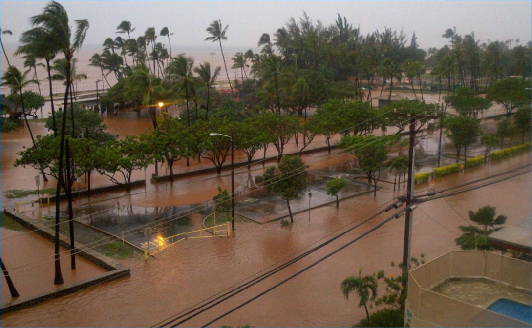
- Most common type of flooding in Hawai‘i.
- Can occur within a few minutes or hours of excessive rainfall.
- Related to runoff and ponding but can also stem from streams or dam failure as a roaring wall of water carrying rocks, mud and other debris.
- Can occur in dry areas if there is heavy rainfall upstream.
River/Stream Flooding
Waterways (rivers or streams) overflow their banks as a result of rainwater or a possible levee breach. (FEMA 2013)
Heavy rains can occur at any time of the year in Hawai‘i; more frequent between October and April (Wet Season).
Coastal Flooding
Flooding along coastal areas can be caused by:
- High surf
- Excessively high tides
- Storm surge
- Tsunami
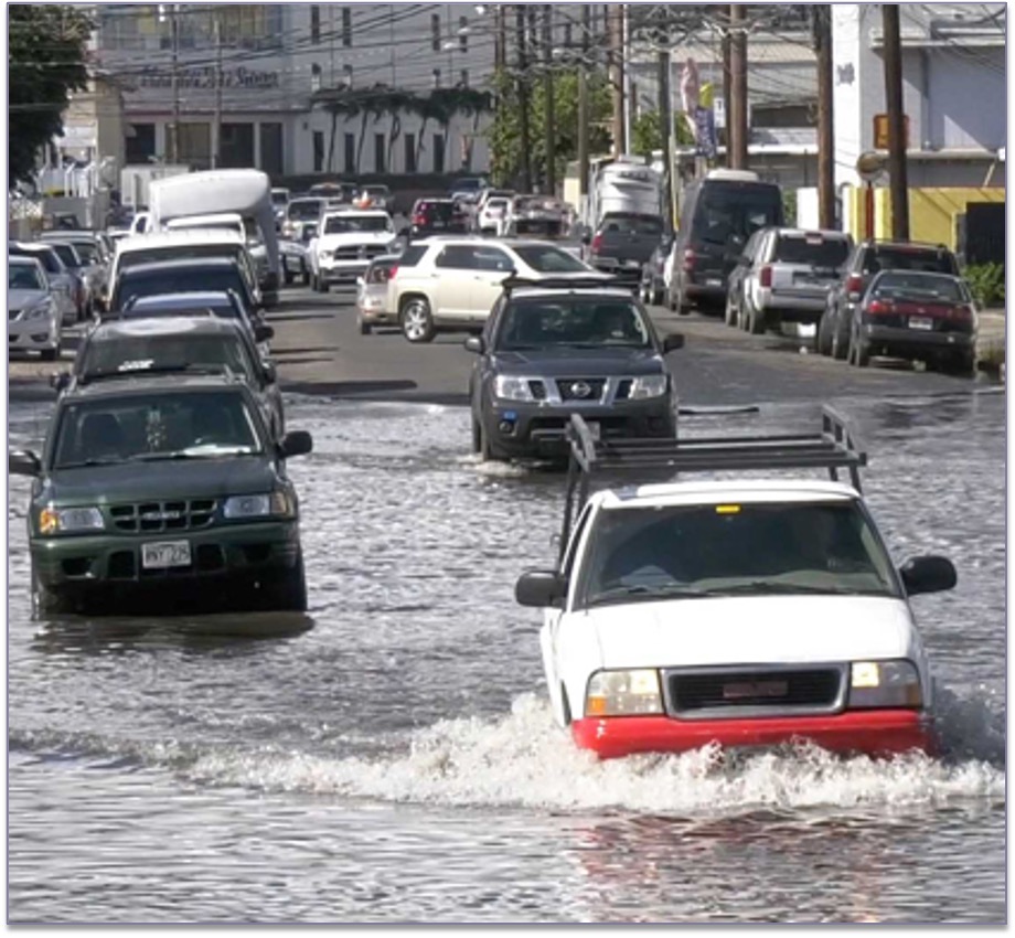
Urban Flooding
Rainfall exceeds the capacity of streets and drains, or underground pipes designed to carry flood waters away from urban areas. (FEMA 2013)
Groundwater inundation (groundwater is pushed up above the ground).
Can also occur when drainage systems become blocked with debris!
Dam Break / Downstream Inundation
Dams/levees hold back vast amounts of water.
Excessive rainfall in a short period of time can cause the dam to overflow.
Huge amounts of water wash downstream in a short time.
Have the potential to destroy property, wash away crops and devastate entire communities.
Causes of structural failure can include:
- Unsuitable construction.
- Lack of, or poor, maintenance.
- Modifications to the original structure (e.g., altering spillway).
- Location in a geologically unstable setting (e.g., prone to earthquakes).
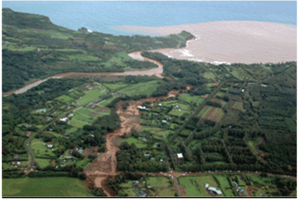
Effects of Flooding
Water
•Flood water may become contaminated with sewage, fuel, chemicals, or other threats.
•High flood water may hide debris or physical hazards under the surface.
•Flood waters can also damage crops.
•Rocks, tree branches, cars – submerged or caught up in the flow of water – can cause damage and block canals and drainage systems.
•Drinking water may be affected if flood waters contaminate water tanks, or if pipes fail in flooded areas.
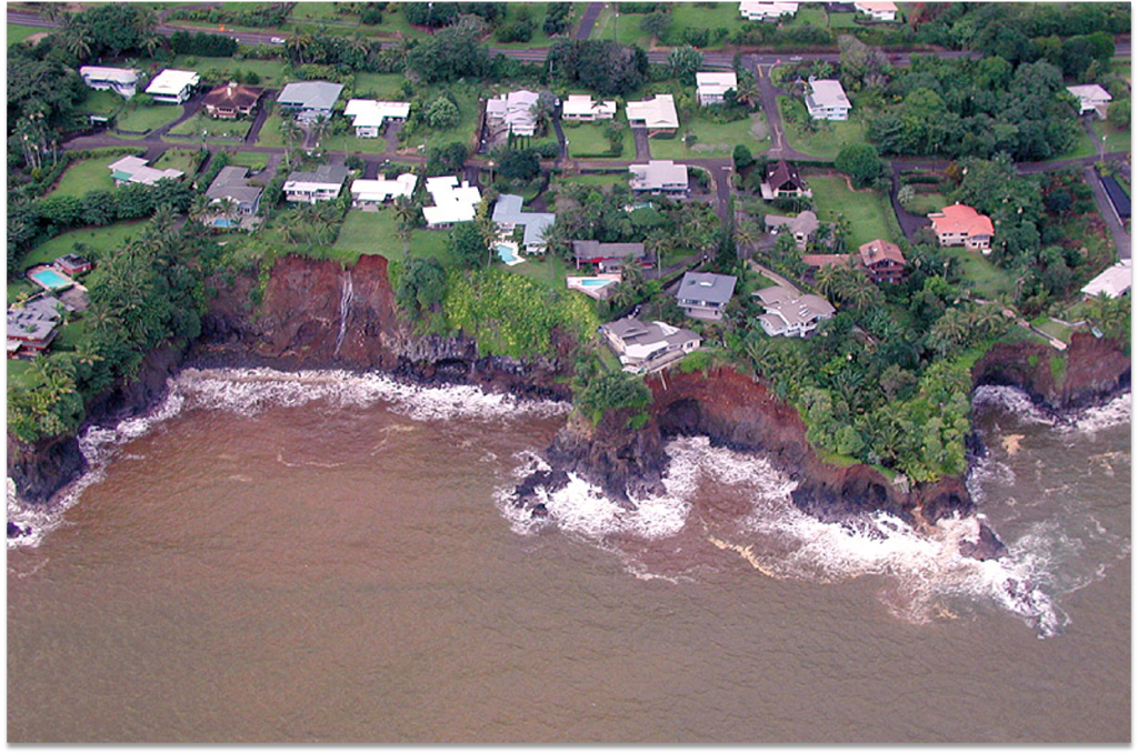
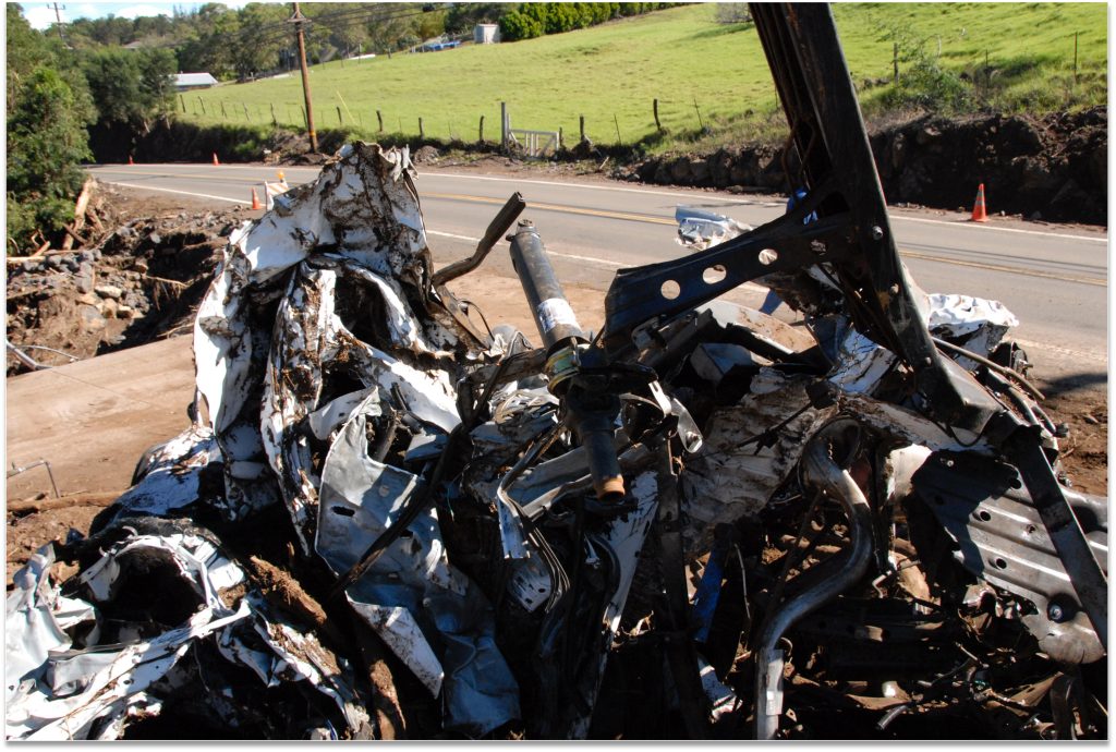
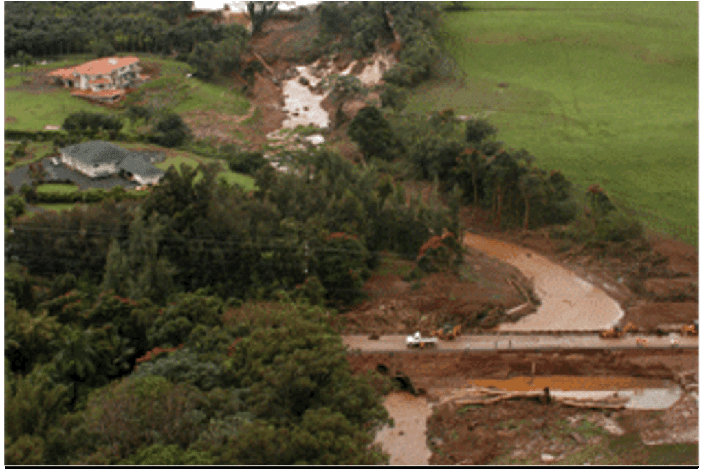
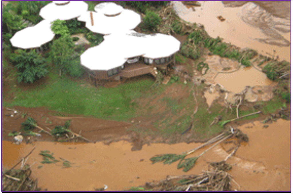
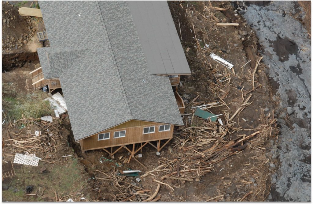
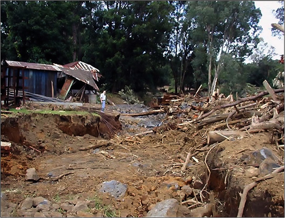
Erosion & Landslides / Mudslides
•Can result when super-saturated soils along steep slopes fail, causing damage to homes.
•Erosion can affect agriculture and top soils.
•Landslides can damage homes, as well as block and damage roads & bridges and cause loss of life.
Flooding Conditions During a Natural Hazard Event Can be exacerbated due to.
High surf conditions
Groundwater inundation – Mapunapuna
Tidal flooding – includes “king tides”
Notable Flood Events
Between 1960 – April 2024: 20 Major Flood-related Disasters were declared in Hawai‘i:
•Eight between the 1960s – 1990s
•Five between 2000 and 2010
•Four between 2011 and 2018
•One in 2020 (Kaua‘i)
•One in 2021 (Kona Low – Maui, O‘ahu)
•One in 2024 (April Floods – Kaua‘i)
Southeast Hawai‘i Island – November 1-2, 2000
•Largest single-day rainfall record for Hawaiʻi island.
•4.56 in. in 1 hour at Hilo Airport.
•22.25 in. in 6 hours at Kapāpala Ranch, Pāhala.
•American Red Cross reported almost 300 homes were destroyed or damaged.
•Damages: over $70 million.
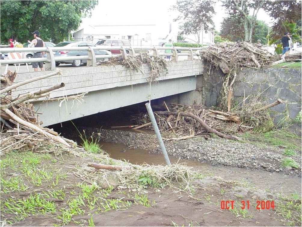
Mānoa Flood – October 30, 2004
•Mānoa Stream overflowed due to a clogged bridge, flooded homes and UH Mānoa’s Hamilton Library, classrooms and laboratories.
•Students in Hamilton Library’s basement had to break a window to escape the rapidly-rising floodwaters.
•About 95% of the 2.8 million items on the library’s first floor were wiped out – including a set of books belonging to Prince Kūhiō.
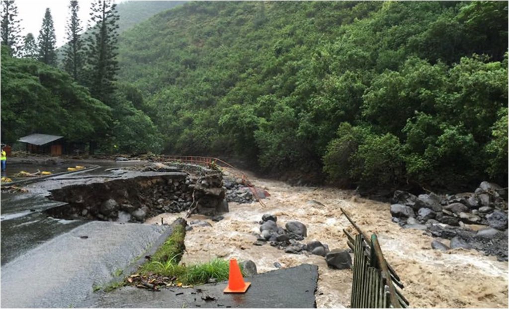
Maui Flood – Sept 11-14, 2016
•Heavy rains caused flooding of Wailuku River; one family had to climb onto their roof to safety.
•The surge of rainwater picked up truck-sized boulders, uprooted giant trees and collapsed parts of Kepaniwai Park and ʻĪao Valley State Monument.
•Damages: over $15 million.
Kaua‘i / O‘ahu Floods – April 2018
•Torrential rainfall and severe flooding over portions of Kauaʻi and Oʻahu.
•Road closures due to landslides isolated communities west of Hanalei, Kauaʻi.
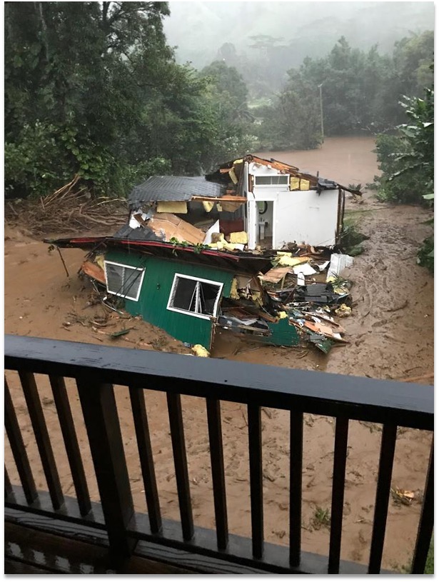
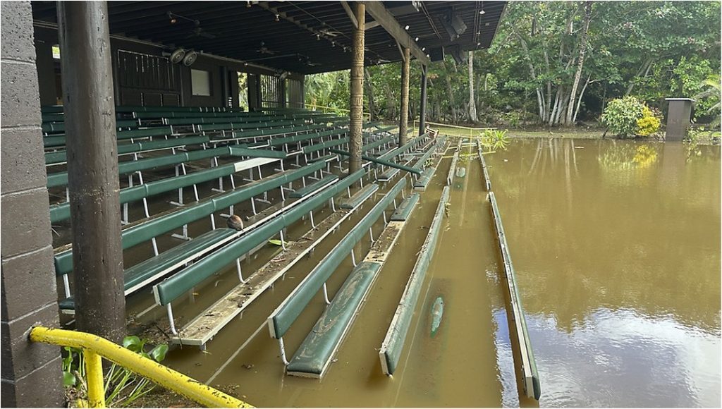
Kaua‘i Flood – April 26, 2024
•Major Disaster Declaration.
•Evacuations in Wailua and Koloa.
•School, park and road closures due to flooding and landslides.
•Spills at two wastewater treatment plants.
•Multiple rescues.
Flood Hazard Zones
Residents can identify areas susceptible to flooding with the Hawai‘i Department of Land & Natural Resources (DLNR) Flood Hazard Assessment Tool:
What does the future hold?
Sea level rise, due to climate change, is increasing the frequency and reach of coastal flooding.
•2017 contained 37 flood days. Historically, the average has been 4 days.
•66,000 people in the state are at regular risk from coastal flooding.
•50% of the population of Kailua, Oʻahu is locked-in below expected flood zones.
Flooding concerns – especially coastal flooding – will increase with climate change. Inland flooding has also increased.
Communities can conduct long- and short-term planning for these events.
Hawaiʻi Flood Hazard Assessment Tool
Alert & Warning
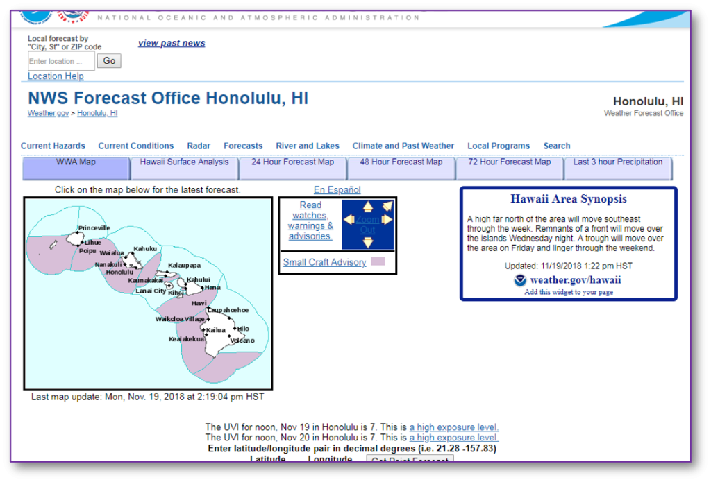
The National Weather Service (NWS) Honolulu is the official source for flood warning information:
•Current conditions and forecasts
•Observational data
•Satellite imagery and radar
•Historical event summaries
Immediate Response Actions
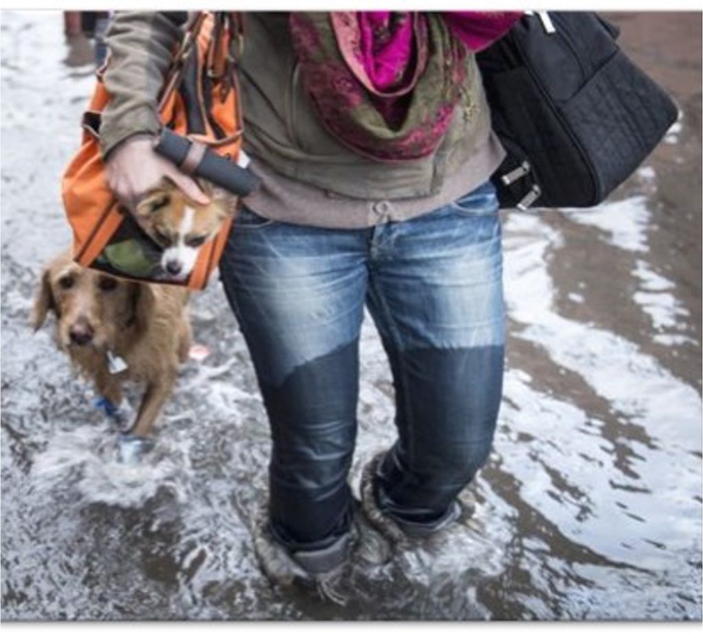
If You Need to Evacuate Your Home
During an Event
•When the alarm sounds or officials instruct you to evacuate, do so immediately.
•Don’t wait until flood waters or storm effects are all around you to evacuate!
•Take your Disaster Supply Kit with you.
•Take your pets with you.
•Follow official advice to get out of the hazard zone.
•Remember! Turn Around, Don’t Drown! Find another route if roads are flooded.
Flood Safety
Check the “lay of the land” at your home and in areas that you visit frequently. If the surrounding land is higher than your location, there is a risk of flooding.
Be aware of the location of dams and retaining basins in your area.
Check the National Flood Insurance Program’s (NFIP) flood zone maps to determine if your home, place of business, school, etc. is located in a flood zone.
Always Remember…
…more people in Hawai‘i die from drowning than from any other weather-related hazard.
For More Information
Central Pacific Hurricane Center
National Hurricane Center
National Weather Service – Honolulu
NOAA NWS StormReady
Hawaiʻi Emergency Management Agency
City & County of Honolulu Department of Emergency Management
Maui County Emergency Management Agencywww.co.maui.hi.us/index.aspx?nid=70
Hawaiʻi County Civil Defense Agency
www.hawaiicounty.gov/civil-defense
Kauaʻi County Emergency Management Agency