Facts on the stability of Kilauea’s south flank, past and present
Posted on May 17, 2018 in 2018 Kilauea Eruption, Declared Disasters, Information and News Releases, MainFacts from the U.S. Geological Survey:
May 14, 2018
There have been several recent highly speculative stories, rumors and blogs about the stability of the south flank of Kīlauea and the potential for a catastrophic collapse that could generate a Pacific-wide tsunami. We wish to put these speculations in their proper context by presenting observations of the current situation and an assessment of past evidence of landslides from Kīlauea.
There is no geologic evidence for past catastrophic collapses of Kīlauea Volcano that would lead to a major Pacific tsunami, and such an event is extremely unlikely in the future based on monitoring of surface deformation. Kīlauea tends to “slump”, which is a slower type of movement that is not associated with tsunamis, although localized tsunamis only affecting the island have been generated by strong earthquakes in the past.
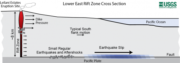
The May 4 M6.9 earthquake resulted in seaward motion of approximately 0.5 m (1.5 ft) along portions of Kīlauea’s south flank as measured by GPS stations across the volcano. A preliminary model suggests that the motion was caused by up to 2.5 meters (8 feet) of slip along the fault that underlies the volcano’s south flank, at the interface between the volcano and the ocean floor, about 7-9 km (4-6 mi) beneath the surface. This motion is within the expected range for a large earthquake on this fault. The earthquake was probably caused by pressure exerted by the magmatic intrusion on the south flank fault, following the pattern of past earthquake activity that has been observed during Kīlauea East Rift Zone intrusions. A small, very localized tsunami did occur as a result of the fault slip. Similar local tsunamis were generated by past large earthquakes, including the 1975 M7.7 and 1868 ~M8 events, both of which resulted in multiple deaths along the south coast of the Island of Hawaii.
Adjustments on the south flank caused another ~9 cm (3.5 inches) of motion at the surface in the day after the earthquake, followed by another 2-3 cm (~1 inch) since May 5. This is higher than the normal rate of south flank motion (~8 cm (3 inches) per year) but is expected as the volcano adjusts after a combination of a magmatic intrusion along the East Rift Zone and a large south flank earthquake. We did observe minor ground ruptures on the south flank, but this is expected given the strength of the May 4 earthquake, and deformation data show that the south flank continues to move as an intact slump block.
Geologic history combined with models of south flank motion suggest that the likelihood of a catastrophic failure event is incredibly remote. There are certainly signs on the ocean floor for landslides from other volcanoes on the Island of Hawaii and from other islands, but none are associated with Kīlauea. In addition, Kīlauea has experienced much larger earthquakes and magmatic intrusions in the recent past. The large earthquakes of 1975 and 1868 were not associated with significant south flank landsliding, nor were major East Rift Zone intrusions in 1840 and 1924.

